Austria
Avalanches, Landslides and Rock fall Austria
Vulnerabilities Austria - Now
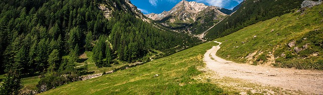
In Austria 74% of all communities are endangered by torrents and avalanches. In some provinces (Carinthia, Vorarlberg, Salzburg, Tyrol) the area threatened by such events amounts to 80% and more of the total (3). Most of the torrent events (93.5%) occur from June to August, that is, during only three summer months (4), and more than 20% of them are dangerous debris flows (1).These risks will increase with climate change (2).
The degradation of mountain permafrost is an additional consequence of persistently high temperatures which can lead to slope instabilities which threaten settlements and communication routes. … In many mountainous regions, tourist resorts such as those in the Alps have spread into high-risk areas, and these will be increasingly endangered by slope instability (1).
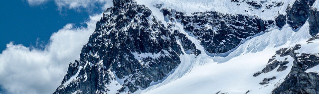
On north facing slopes in the Alps, permafrost occurs at altitudes above 2600 m, on south facing slopes above 3000 m, and in zones with long-lasting avalanche snow at altitudes several hundred metres lower (5). Permafrost is also sensitive to snow cover, topography, aspect and ground surface material (6).
Recent studies show ongoing permafrost warming in the European Alps: during the twentieth century, permafrost warmed by 0.5 to 0.8°C in the upper tens of metres (7), particularly at higher elevations, with accompanying thickening of the seasonal active layer (8). Changes in snow cover thickness and duration also affect sub-surface temperatures and permafrost distribution (7,8); therefore decreasing snowfall will promote permafrost degradation, irrespective of changes in air temperature.
The European Alps is sensitive to such changes because it is located at the boundary between different moisture source regions, its glaciers and permafrost are in long-term decay, and hazardous events can readily impact on areas of high population density in alpine valleys (13).
The geomorphological and wider landscape impacts of the 2003 and 2005 events can be considered analogous to the probable hazardous impacts of future climate changes in the eastern European Alps, under which meteorological variability will be more common. In turn, this has implications for risk management in the Alps (13).
Global warming and mountaineering
Glacier retreat and permafrost degradation seem to be the two most important processes in the context of global warming and mountaineering. Both provide additional rock material for different kinds of mass movement processes. Unstable material provides new potential starting zones for different kinds of mass movements such as debris flows, landslides, or rockfall. Numerous classical ice climbs in the Eastern Alps have become heavily affected by rockfall and falling stones as well due to rocks melting out at the ice margins (26).
Both glacier retreat and permafrost degradation can also reduce morphodynamics locally, thereby decreasing the occurrence of natural hazards (27). Hence, it cannot be generally stated that the mountains are becoming more dangerous throughout. There is still little known about the frequency of the mentioned hazard events, and to date there are no time series available to prove that these events have become more frequent in the long run (27).
The impact of a hot summer: 2003
The summer of 2003 was characterized by the hottest temperatures in the last 500 years in Central Europe (9) and the warmest summer in a 1250 year long record for the European Alps (10). Summer precipitation in Austria and Switzerland was only 50 per cent of average (11), which had also been preceded by a dry spring (February–June).
In 2003 the thaw depth in permafrost on bedrock slopes was twice the average of previous years and indicates a strong coupling between atmospheric and ground temperatures (7). Permafrost degradation set into action by this warming was reflected in increased rock-fall activity throughout the Alps during summer 2003 (7). In particular, localities near the lower elevational limit of the discontinuous permafrost are very sensitive to changes, and respond with a short time lag (of days–months). For example, a large rock-fall event at the elevation of the lower permafrost boundary on the Matterhorn (Switzerland), July 2003, revealed weakened interstitial ice at the back of the rock-fall scar (12). Large-scale responses to warming permafrost, such as deep-seated slope instabilities, may show a delay of decades or centuries (7,8).
The observed increase in periglacial and glacial hazards, as during the 2003 event, is concentrated in high-altitude areas where it impacts on small settlements and mountaineering/skiing infrastructure (paths, huts). Public awareness of these mountain hazards (as opposed to floods and snow avalanches) is generally low. Despite a low direct effect on society, these high-mountain hazards increase the availability of easily mobilized debris and so increase future hazard risk. The 2005 event showed the connectivity between process chains or cascades resulting from such mountain-hazard events, which lead in turn to high sediment transport through landslides and other processes, and their impacts on valley settlements (13).
The impact of heavy downpour: 2005
In August 2005, Central Europe and especially the Alpine region was affected by severe floods accompanied by river-bank erosion and sediment transport, as well as debris flows, rock falls and landslides in the smaller catchments (14). These events caused the most catastrophic flood damage in the last 100 years with respect to loss of life and damage to infrastructure, communication routes and agriculture (15). In Switzerland, the August 2005 event caused one quarter of all damage by floods, debris flows, landslides and rock falls recorded since 1972 (16).
In Austria alone, 115 debris flows and 111 other landslides were recorded (17), mainly with medium to high sediment volumes. A few debris-flow events transported more than 100,000 m3of sediment (14). A substantial part of the sediment load (debris and woody debris) accumulated as torrent fans in the main valleys. Some of the debris flows delivered their sediment load into mountain rivers and contributed to the high sediment transport in the river downstream, in addition to the sediment produced locally (14). The strong geomorphological activity during the flood event resulted in changes to channel courses, enhanced bank overtopping and sediment deposition outside the main channels. This led to substantial flood damage on inhabited areas and infrastructure along the river channels (14).
The 2005 event caused losses of up to 555 million Euro across Austria, of which 442 million Euro occurred in the western states of Austria (18).
Austria uses design events with a 100 year recurrence interval for floods and 150 years for debris flows. The 2005 event was far beyond these design events and therefore historical experience, meaning that the record of past events is no longer sufficient for hazard assessment. ... The role of climate change in the Alps, which the 2003 and 2005 events probably prefigure, has significant implications for hazard triggering and mitigation (13).
In 2005, Austria spent a total of EUR 122 million on preventive measures against torrential flooding, avalanches and erosion, with the federal government providing EUR 69 million of that (2).
The impact of wildfires
Rockfall risk is related to the risk of wildfires. Increased rockfall activity of rather smaller rock blocks is recognizable during as well as after the wildfire. The destabilization of small rock blocks and the burn of tree roots may also cause the destabilization of larger rock masses (36).
Vulnerabilities Austria – In the future
Avalanche
A change in avalanche hazards in connection with climate change is uncertain. In general, it is assumed that the possible change would follow the snow cover evolution. A decrease in avalanche hazards is likely at low and medium altitudes. Yet, heavy precipitation events might counterbalance this trend by triggering general avalanche situations (19).
Alpine mass movements
The degradation of permafrost in steep slopes is a major factor for the reduced stability of rock walls and the rock fall pattern. Increased precipitation might lead to more frequent and extended slope instabilities in the future. In particular, the changes of intense precipitation could impact the shallow landslides (through the surface water runoff and stream actions), while the changes of long-term precipitation could impact the deep landslides (through underground water action). On the other hand, the possible future decrease of summer precipitation may have a positive effect by reducing the deep and shallow landslides activity (19).
The zone of warm permafrost (mean annual rock temperature approximately -2 to 0°C), which is more susceptible to slope failures than cold permafrost, may rise in elevation a few hundred meters during the next 100 years (20). This in turn may shift the zone of enhanced instability and landslide initiation toward higher-elevation slopes that in many regions are steeper, and therefore predisposed to failure.
The projected glacier retreat in the 21st century may form new potentially unstable lakes. Probable sites of new lakes have been identified for some alpine glaciers (21). Rock slope and moraine failures may trigger damaging surge waves and outburst floods from these lakes.
IPCC conclusions in 2012
In 2012 the IPCC concluded that there is high confidence that changes in heat waves, glacial retreat, and/or permafrost degradation will affect high mountain phenomena such as slope instabilities, mass movements, and glacial lake outburst floods, and medium confidence that temperature-related changes will influence bedrock stability. There is also high confidence that changes in heavy precipitation will affect landslides in some regions (22). There has been an apparent increase in large rock slides during the past two decades, and especially during the first years of the 21st century in the European Alps (23) in combination with temperature increases, glacier shrinkage, and permafrost degradation.
There is medium confidence that high-mountain debris flows will begin earlier in the year because of earlier snowmelt, and that continued mountain permafrost degradation and glacier retreat will further decrease the stability of rock slopes. There is low confidence regarding future locations and timing of large rock avalanches, as these depend on local geological conditions and other non-climatic factors (22). Research has not yet provided any clear indication of a change in the frequency of debris flows due to recent deglaciation. In the French Alps, for instance, no significant change in debris flow frequency has been observed since the 1950s in terrain above elevations of 2,200 m (24). Processes not, or not directly, driven by climate, such as sediment yield, can also be important for changes in the magnitude or frequency of alpine debris flows (25).
IPCC conclusions in 2019
Rock fall
The IPCC concluded in 2019 that there is high confidence that the frequency of rocks detaching and falling from steep slopes (rock fall) has increased within zones of degrading permafrost over the past half-century, for instance in high mountains in Europe (29). Available field evidence agrees with theoretical considerations and calculations that permafrost thaw increases the likelihood of rock fall (and also rock avalanches, which have larger volumes compared to rock falls) (30). Summer heat waves have in recent years triggered rock instability with delays of only a few days or weeks in the European Alps (31).
Snow avalanches
In the European Alps, avalanche numbers and runout distance have decreased with decreasing snow depth and increasing air temperature (32). In the European Alps and Tatras mountains, over past decades, there has been a decrease in avalanche mass and run-out distance, a decrease of avalanches with a powder part since the 1980s, a decrease of avalanche numbers below 2000 m, and an increase above (33).
Future projections mostly indicate an overall decrease in snow depth and snow cover duration at lower elevation, but the probability of occurrence of occasionally large snow precipitation events is projected to remain possible throughout most of the 21st century (29). An overall 20 and 30% decrease of natural avalanche activity in the French Alps is estimated for the mid and end of the 21st century, respectively, under a moderate (A1B) scenario of climate change, compared to the reference period 1960 – 1990 (34). The overall number and runout distance of snow avalanches is projected to decrease in regions and elevations experiencing significant reduction in snow cover (35)
Avalanches involving wet snow are projected to occur more frequently during the winter at all elevations due to surface melt or rain-on-snow (34, for the French Alps).
In summary, there is medium evidence andhigh agreement that observed changes in avalanches in mountain regions will be exacerbated in the future, with generally a decrease in hazard at lower elevation, and mixed changes at higher elevation (increase in avalanches involving wet snow, no clear direction of trend for overall avalanche activity) (29).
Adaptation strategies
Austria as an alpine country, is used to adapt to environmental risks since centuries. This permanent implementation of new adaptation measures motivated by socio-economic and land use changes, are beneficial for adapting to a climatic change (1).
Forests provide natural protection against torrential flooding, avalanches and erosion, and around 20% of all the forest in Austria has some form or protective function. In 2002, the Austrian Protection Forest Strategy was published, setting out the future of the forest and its protective function, and how to keep any beneficial properties intact through forestry (2).
The Forest Engineering Service in Torrent and Avalanche Control is therefore working to prepare and assess the production of “hazard zone maps”, with almost the whole of Austria now mapped. Although they are not legally obliged to follow these maps, they are used by the Länder (regions) and the construction sector, as the basis for drawing up outline and detailed plans (2).
Adaptation strategies - AdaptAlp
According to AdaptAlp, a project of the six Alpine countries on natural hazards in the Alpine region, the ten most significant actions required at this time to prepare for the risks caused by global warming in the Alps are (28):
- Improve public preparedness and personal responsibility by encouraging participation in emergency planning. To properly inform the public, risk management plans must address both emergency preparedness and early warning systems.
- Incorporate climate change adaptation into spatial planning. A few examples to create a sustainable regional development that is less vulnerable to natural hazards are: financial incentives, establishing hazard zones, setting appropriate construction standards of buildings and infrastructure in risk areas, keeping endangered spaces free of development, and performing hazard assessments through the use of hazard mapping.
- Involve local stakeholders in a risk dialogue. The dialogue includes meetings between important stakeholders, such as land and real estate owners, as well as those responsible for infrastructure and the public sector.
- Encourage cross-border networking on integrated risk management.
- Encourage a ‘common language’ and harmonised procedures when developing and using hazard maps.
- Increase the size of flood plains, floodwater conduits and basins. Governments need to consider multiple uses of the same land and consider strict legal binding instruments that ensure a priority for flood retention areas is given.
- Think of flood risk management in terms of an entire river basin to find solutions that are sustainable. Horizontal and vertical cooperation between all levels of government and the private sector are essential.
- When planning for natural hazard risks consider all the environmental risks within a defined area. Natural hazards—floods, droughts, landslides—generate risks that are interrelated and so should be addressed jointly.
- Use risk-management tools to explore the social and economic consequences of various adaptation measures. Risk planning tools allow for the integration of a wide range of strategies that reduce the risks of natural hazards, including spatial planning instruments, technical protection structures, specific protection measures for individual buildings and early-warning systems.
- Support the collection and interpretation of local climate change data.
References
The references below are cited in full in a separate map 'References'. Please click here if you are looking for the full references for Austria.
- Federal Ministry of Agriculture, Forestry, Environment and Water Management (2010)
- Swedish Commission on Climate and Vulnerability(2007)
- BMLF (1996), in: Federal Ministry of Agriculture, Forestry, Environment and Water Management (2010)
- Andrecs (1995), in: Federal Ministry of Agriculture, Forestry, Environment and Water Management (2010)
- Haeberli (1975); Lieb (1998); Luetschg et al. (2008), all in: Keiler et al. (2010)
- Damm (2007), in: Keiler et al. (2010)
- Gruber et al. (2004)
- Harris et al. (2003), (2009), in: Keiler et al. (2010)
- Luterbacher et al. (2004), in: Keiler et al. (2010)
- Büntgen et al. (2006), in: Keiler et al. (2010)
- Patzelt (2004); Schmidli and Frei (2005), both in: Keiler et al. (2010)
- Nötzli et al. (2004), in: Keiler et al. (2010)
- Keiler et al. (2010)
- Rickenmann et al. (2008), in: Keiler et al. (2010)
- Beniston (2006); Frei (2006), both in: Keiler et al. (2010)
- Hilker et al. (2008), in: Keiler et al. (2010)
- Internationale Forschungsgesellschaft Interpraevent (2009), in: Keiler et al. (2010)
- BMLFUW (2006b), in: Keiler et al. (2010)
- ESFR ClimChAlp (2008b), in: Castellari (2009)
- Noetzli and Gruber (2009), in: IPCC (2012)
- Frey et al. (2010), in: IPCC (2012)
- IPCC (2012)
- Ravanel and Deline (2011), in: IPCC (2012)
- Jomelli et al. (2004), in: IPCC (2012)
- Lugon and Stoffel (2010), in: IPCC (2012)
- Schwörer (1999), in: Ritter et al. (2012)
- Lieb et al. (2007), in: Ritter et al. (2012)
- AdaptAlp
- IPCC (2019)
- Gruber and Haeberli (2007); Krautblatter et al. (2013), both in: IPCC (2019)
- Allen and Huggel (2013); Ravanel et al. (2017), both in: IPCC (2019)
- Teich et al. (2012); Eckert et al. (2013), both in: IPCC (2019)
- Eckert et al. (2013); Lavigne et al. (2015); Gadek et al. (2017), all in: IPCC (2019)
- Castebrunet et al. (2014), in: IPCC (2019)
- Mock et al. (2017), in: IPCC (2019)
- Melzner et al. (2019)


