

Germany
Transport, Infrastructure and Building Germany
Vulnerabilities - Transport - Shipping
Navigation is negatively impacted by frost and ice in winter. Icing over of surface waters impairs navigation and causes the need to use icebreakers. In cold winters, navigation may also be shut down completely (1).
Of even more importance is the influence of climate on the water levels of rivers. At high water, navigation often has to be restricted, since rapid velocities of river flows endanger the ships, or because already flooded areas cannot tolerate the waves caused by navigation. During arid periods, water level can sink below a critical level, so that the discharge of cargo ships is no longer warranted. Particularly, free flowing rivers (e.g. Elbe, Rhine, Weser) are impacted by climate–induced fluctuations of water levels. In regulated rivers, water level fluctuations can to some extent be buffered by damming. Finally, seaports and navigation of coastal waters can be impacted by sea level rise (1).
The German adaptation strategy makes a distinction between free-flowing rivers and backed-up waterways, which include canals. The crucial factor for the latter is long-term changes in water supply, because in the short
and medium term the water level can be kept stable by means of locks and weirs. By contrast, freeflowing rivers are of little or no use as inland waterways during periods of extreme low or high water (5).
River Rhine
For the Rhine, low flow situations with water-levels below a certain threshold for navigation have occurred throughout the 20th century. A clear trend is not discernible in the data, however, neither in the duration nor in the frequency of low flow situations (9).
In countries like the Netherlands, Belgium and Germany, inland waterway transport has a substantial share in freight transport (measured in ton-kilometers or ton-miles) with 33, 18 and 13 % in 2010, respectively (13). Both in the dry cargo Rhine fleet and in the tanker Rhine fleet, the Dutch fleet forms about 50 % of total capacity. The Rhine corridor is by far the most important inland waterway in Europe in terms of volume transported (63 % of total volume in Europe in 2006). This is mainly because the Rhine connects the seaports of Rotterdam, Amsterdam and Antwerp with large industrial areas in Germany. The cargo types most transported are metal ores, coke and petroleum products, followed by coal.
At extremely low water levels, the price per tonne for inland waterway transport in the river Rhine area will almost double. These increased transport prices result in welfare losses. For the dry summer of 2003, the losses for North West Europe have been estimated to sum up to around €480 million. Shipping may benefit from the low water periods because the temporary reduction in capacity may have a further upward pressure on prices. The clients of the inland waterway transport sector will in the end shift the burden to the final consumers. This means that the economic effects of low water levels are diffused thinly across large groups of consumers (12).
Rhine-Main-Danube corridor
The impact of hydrological changes on navigation conditions has been studied for the Rhine-Main-Danube corridor, one of the most important waterways in Europe (10). Four impacts were studied: low flow, floods, ice and visibility (fog).
- Low-flow threshold: In this study, the low water threshold for navigation has been defined as the 95th percentile of the flow-duration curve for the period 1961-1990. For the River Rhine this threshold is currently (1961-1990) undershot on about 18 days per year. For the River Danube, where only monthly discharge data are available, this threshold is interpreted as the number of months the monthly 95th percentile is undershot in a 30-year period (at the gauge Vienna). Since the 1970s the number of days with discharge lower than the low-flow threshold has decreased at the Rhine gauges Kaub and Ruhrort. Beginning in the early 1990s there was a decade with only a few days below this threshold. The year 2003 was the first year of a period when longer low flow situations re-occurred. At the gauges on the River Danube similar tendencies were observed during the 20th century as on the River Rhine (10).
- Floods: At high water levels, navigation may be restricted in terms of speed limits, the concentration of traffic in the centre of the fairway (to reduce wave stress on the lateral infrastructure) and (at the highest threshold) a general stoppage of navigation. For both the Rhine and the Danube, neither a trend nor a tendency is obvious from the data at the studied gauges (10).
- River ice: With respect to the Rhine-Main-Danube corridor, ice is mainly an issue for the River Main, the RMD canal and the River Danube. Since 1950 the number of days with stoppage of navigation due to river ice has decreased (10).
- Visibility: Meteorological phenomena can reduce visibility and thus can harm vessels that navigate on sight. Vessels without radar systems can be stopped according to official regulations. But also vehicles with radar have to operate with care, which often means loss of time due to speed limits and slower manoeuvring. A distinct reduction of the number of days per year with low visibility has been observed at all stations in the 1970s (10). This may be the result of a strong decline of aerosol emissions over Europe (11).
Vulnerabilities - Transport - Road
In winter, snowfall, ice, fog and hail impede road traffic. This leads to slow speeds of traffic, traffic jams, and an increase in the risk of accidents. Moreover, frost causes damages to roads and bridges. Strong rainfall events lead to floods and the erosion of slopes, which disrupt traffic in the short-term and can also lead to permanent damages of transport infrastructure. Other extreme events, such as storm and hail, also cause great damages, primarily to vehicles (1).
Higher mean temperatures in winter could prove an advantage for the infrastructure: frost damage to roads and bridges will be less frequent. There could also be a reduction in the number of accidents due to snow and ice (5).
Heat waves in summer impair the concentration of drivers and can lead to an increase in the risk of accidents. According to a study of the Federal Office for Road Traffic, the number of accidents increases by 13% outside cities, and by 22% inside cities when the temperature inside vehicles is above 32ºC (2). Extreme temperatures of above 37ºC even increased the number of accidents by 33%. Moreover, high temperatures cause damages to road paving (e.g. lane grooves).
Vulnerabilities - Transport - Rail
Rail traffic is less dependent on weather than road traffic. In winter, mainly icing of the power supply can impact rail traffic. In summer, particularly weather extremes are important. These include damages to overhead contact lines (catenaries) through storms, the uprooting of trees through storms, undercutting of railroad tracks through heavy rainfall and floods, as well as track damages through extreme heat (1). Fires on adjacent slopes could become more common if conditions are hotter and drier (5).
Vulnerabilities - Transport – Air traffic
Weather influences efficiency and safety of air traffic. Air transport is sensitive primarily to thunderstorms, strong winds, mist, fog, rain, snow and ice on the ground and in the air. Winter weather conditions on airports are a frequent cause of delays and potential hazards (3). All larger airports in Germany respond to these dangers with a complex system of winter maintenance procedures (1). Air traffic will only be marginally affected by possible climate changes (5).
Vulnerabilities - Buildings
The changing climate has the potential regionally to increase premature deterioration and weathering impacts on the built environment, exacerbating vulnerabilities to climate extremes and disasters and negatively impacting the expected and useful life spans of structures (6).
Vulnerabilities - Infrastructure
Small increases in climate extremes above thresholds or regional infrastructure ‘tipping points’ have the potential to result in large increases in damages to all forms of existing infrastructure nationally and to increase disaster risks (7). Since infrastructure systems, such as buildings, water supply, flood control, and transportation networks often function as a whole or not at all, an extreme event that exceeds an infrastructure design or ‘tipping point’ can sometimes result in widespread failure and a potential disaster (8).
Future vulnerabilities - Transport - Shipping
It is projected that the future duration and frequency of low flow situations for the German Rhine may not be very different from those observed in the past, with one exception: the frequency of long lasting low flow situations (>35 days) seems to increase. The uncertainty of future projections is large, however (9).
Rhine-Main-Danube corridor
In Europe, the highest amount of cargo by means of inland waterways is transported in the Rhine–Main–Danube corridor. In this corridor, no decrease in the performance of inland waterway transport due to extreme weather events is expected till 2050 (17). Extreme weather events relevant to inland waterway transport are low-water events (drought), high-water events (floods) and ice occurrence. Of less importance are wind gusts and reduced visibility. There is no convincing evidence that low-water events will become significantly severer on the Rhine as well as the Upper Danube in the near future. However, on the Lower Danube, some impact of drought in association with increased summer heat might appear. Severe low-water situations seem to become more important in the period 2071–2100. A quantitative conclusion on the future effects of high water on inland waterways cannot be drawn at this stage (17).
Ice occurrence is decreasing, due to global warming, as well as human impacts leading to shorter periods of suspension of navigation in regions where navigation may be prevented by ice. In fact, the Upper and Middle Rhine navigation has not been suspended due to ice since at least the 1970s (18). For the near future (until 2050), wind gusts are expected to remain on the same level as today (19), thereby not decreasing the safety of inland waterway transport. Visibility seems to improve, if the results for European airports are considered (19), thereby improving the safety of inland waterway transport as well as operation of inland waterway vessels.
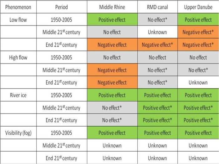
The impact of hydrological changes on navigation conditions for the Rhine-Main-Danube corridor has been studied for a number of climate change projections (for the River Rhine: 27 projections including different emission scenarios; for the Upper River Danube: 20 projections including emission scenario A1B only). Estimated changes are generally given for the period 1950 to 2050, sometimes also for the period 1850 to 2100. Four impacts were studied: low flow, floods, ice and visibility (fog) (10). The results are summarized in the table below.
- Low-flow threshold: In this study, the low water threshold for navigation has been defined as the 95th percentile of the flow-duration curve for the period 1961-1990. For the River Rhine this threshold is currently (1961-1990) undershot on about 18 days per year. For the River Danube, where only monthly discharge data are available, this threshold is interpreted as the number of months the monthly 95th percentile is undershot in a 30-year period (at the gauge Vienna). For the near future (up to 2021-2050) all discharge projections for the Rhine except one show that the number of days below the low-flow threshold for 1961-1990 will remain in the range that has been observed since the 1950s at gauge Kaub. For the distant future (2071-2100) some projections still show a reduced number of days below this threshold, while a majority of the projections shows a higher than present number of days below this threshold. These projections show a continuation of the shift of the low-flow season from winter to summer, which has already been observed in the last decades. The low-flow situations tend to become more extreme (in terms of intensity and duration) at the end of the 21st century. For the Danube (at gauge Vienna) the majority of the projections for the near future (2021-2050) shows a moderate increase in the number of months below this low-flow threshold, whereas the distant future (2071-2100) shows that the present low-flow threshold will be undershot more frequently. The shift of the low-flow season from winter towards summer is simulated to occur in the distant future (not in the near future).
- Floods: At high water levels, navigation may be restricted in terms of speed limits, the concentration of traffic in the centre of the fairway (to reduce wave stress on the lateral infrastructure) and (at the highest threshold) a general stoppage of navigation. In this study the flood threshold for the River Rhine was defined as a discharge that is exceeded on 3% of the days per year in the mean of the period 1961-1990. For the River Danube this definition could not be applied because only monthly discharge data were available. For the near future (up to 2021-2050), most of the projections for the Rhine point towards a higher number of days than at present when navigation is restricted due to floods. Most projections are clustered in a range between 11 and 20 days per year. For the distant future (2071-2100), the span of results is much wider; also here, a majority of the projections shows more days above the threshold, ranging between 8 and more than 30 days per year. For the Upper Danube no clear picture can be given yet of the future development in the number of days with restricted navigation due to high flow.
- River ice: With respect to the Rhine-Main-Danube corridor, ice is mainly an issue for the River Main, the RMD canal and the River Danube. The number of days with stoppage of navigation due to river ice will continue to decrease. The projected reduction towards ever less restrictions for navigation due to river ice is particularly pronounced in the last decades of the 21st century.
- Visibility: Meteorological phenomena can reduce visibility and thus can harm vessels that navigate on sight. Vessels without radar systems can be stopped according to official regulations. But also vehicles with radar have to operate with care, which often means loss of time due to speed limits and slower manoeuvring. Due to current limitations of the regional climate models it is not possible to directly conclude on the number of days with fog occurrence for future time horizons. Besides, also non-climatic factors (such as effects of urbanisation) control fog formation.
Table: Summary of (projected) effects of climate and hydrological change on navigation on the Rhine-Main-Danube corridor for the second half of the 20th century (tendency 1950 to 2005), the mid 21st century (change 2021-2050 vs. 1961-1990) and the end of the 21st century (change 2071-2100 vs. 1961-1990). The findings marked by * were not directly observed or modelled but concluded from other findings (e.g. approximate indicators, neighbouring regions or from literature) (10).
Bulk cargo companies vulnerabilities at low water on the Rhine
Mass-cargo-affine companies are companies that depend on mass cargo, like coal fired power plants, chemical industry or steel industry. Traditionally they settle along river banks to be able to use inland navigation as a cheap and reliable way of transport. During low water periods however, the capacity of inland navigation vessels is reduced and therefore the transport amount is limited, while the transport demand stays on the same high level. This affects their security of supply. The vulnerability of bulk cargo companies along the River Rhine to low water periods has been studied for the near future (2021–2050) and the distant future (2071–2100), and compared with the period 1961–1990. The future projections are based on results of a number of climate models and two IPCC SRES emissions scenarios (B1 and A1B) (16).
A discrepancy between the transport amount and the transport demand may result in a deviation of optimal storage and may thus affect continuity of business processes. The projected deviation of optimal storage was largest in autumn: -1.5% (B1-scenario) to -6 % (A1B) for 2021–2050, and -8% (B1 scenario) to -15% (A1B) for 2071–2100. Analysis of the inter-annual variability shows that, in individual years, individual companies may experience up to 18 (B1 scenario) or 45 days with empty storage toward the end of the century, most of them in a row in late summer and autumn. Also the number of years with days with empty storage increases. While till 2050 only one to two years per decade show days with empty storage, in the second half of the century on average at least every second year, shows days with empty storage (16).
Future vulnerabilities - Transport - Road
With regard to the impacts of climate change on transport, it is anticipated that winter restrictions through frost and ice will decrease in future. This will profit all transport means equally. Impacts on transport are primarily to be expected from an increased frequency of extreme events. Hot summer temperatures will primarily impair road traffic.
Adaptation strategies
Transport shipping
Examples of adaptation measures for inland waterway transport are (9):
- reduction of weight of ships by changed material, construction or equipment to avoid reduction in load capacity in low flow situations;
- improved steering technology and manoeuvrability, and improved training of crews to reduce risk of damage in low flow situations;
- 24 h operation, reserve of tonnage, increased storage capacity, cooperation with other modes of transport, and improved forecast systems (extended lead times, seasonal forecasts) to enhance flexibility;
- improved navigation systems to avoid reduction in load capacity in low flow situations, and to reduce risk of damage in low flow situations;
- digging and river regulation to avoid reduction in load capacity in low flow situations.
In the short run, adaptation to low water periods can take place via modal shift to road and rail transport to avoid the high prices in water transport. Studies indicate that this shift will be modest (5–8 %) because even with low water, barges remain cheaper than their competitors on most of the relevant markets (14). Other options to adapt to low water periods on the short-term are to move barges from submarkets not affected by low water to markets that are affected and to make old barges that were withdrawn from the fleet operational again. On the long-term intensified water management (e.g., dredging) is most probably the more promising way to adapt to climate change (15). Adjustment to smaller ship size is unlikely; the advantages of large ships are so large that the current trend of increasing ship sizes may be expected to continue even when low water intervals become more frequent (12).
Bulk cargo companies may reduce their vulnerability to low water on the river, and thus ensure continuity of business processes, by increasing their storage capacity for mass cargo. According to projections for the River Rhine, in 2021–2050 2.5% and in 2071–2100 25% extra storage capacity is needed to compensate the impact of lower water-levels in autumn (16).
Improved water management and the construction of new dams can counteract fluctuating water levels in rivers. However, such large-scale technological intervention measures are costly, and can conflict with other objectives, in particular goals in nature conservation. In areas where navigation could only be sustained with large technological interventions, a shift to rail transport should be considered (1).
The Federal Ministry of Transport, Building and Urban Affairs (BMVBS) has initiated the KLIWAS ("impacts of climate change on waterways and shipping") research programme with a view to developing reliable adaptation strategies and measures for shipping and the waterway network (4).
Transport road
Possible technological adaptations to climate change are using new heat-resistant materials in transport infrastructure (e.g. new pavements), air conditioning in cars, measures against extreme events (e.g. protection against mudflows and relocation of routes (in potential flood areas)) (1). Intense rainfall can be drained away by providing roads with larger-capacity drainage systems (5).
Building
Buildings and infrastructure facilities are frequently used for more than a hundred years. The federal and länder authorities should therefore adapt building standards to take account of climate change (5).
Flood risk reduction via land-use planning
Zoning policies can be used to limit the exposure to flooding of people and assets. Zoning regulations entail the determination of areas with a certain flood risk (i.e. the 100-year flood zone) and setting up certain land-use requirements for these zones (20). In Germany, the area affected by a 100-year flood plays an important role for flood risk management (22). In this area, land use is often restricted, and most flood defences (e.g. levees, flood retention basins) are designed to protect up to this flood level (23).
Spatial planning can also play a role in limiting fatalities by optimising the possibility to reach safe places in case of flooding, be it within the flooded region (vertical evacuation, for instance to higher floors or designated flood shelters) or out of the affected region (horizontal evacuation). In addition, spatial planning can facilitate the evacuation of people away from threatened areas by making sure the main road network is elevated and thus able to be used longer in case of flooding (20). Old levees or local embankments can potentially be used for this and may have an extra compartmentalisation effect (21). Such compartmentalisation could limit the flood extent and thus fatalities and damage as well (20).
Flood risk reduction via private damage-reducing measures
During recent years in Germany, private responsibility for flood damage reduction has been increasingly emphasised and embedded into flood risk management (24). According to § 5 of the German Federal Water Resource Act that was enacted in 2009, every person that could be affected by a flood is obliged to undertake appropriate actions that are reasonable and within one’s means to reduce flood impacts and damage (25).
Communication
In Germany, outside the scientific community climate change is so far discussed almost exclusively in the context of the need for emission reductions. Adaptation to the impacts of climate change has only recently received more attention, but is still highly under-represented in public awareness and in the consciousness of decisionmakers in economy, policy and administration. With regard to this, the first step towards a Germany that is adapted to the impacts of climate change is to raise awareness of its risks and opportunities – a task of communication (1).
References
The references below are cited in full in a separate map 'References'. Please click here if you are looking for the full references for Germany.
- Zebisch et al. (2005)
- Arminger et al. (1995), in: Zebisch et al. (2005)
- Hauf et al. (2004), in: Zebisch et al. (2005)
- Government of the Federal Republic of Germany (2010)
- Federal Ministry for the Environment, Nature Conservation and Nuclear Safety (2009)
- Auld (2008b); Larsen et al. (2008); Stewart et al. (2011), all in: IPCC (2012)
- Coleman (2002); Munich Re (2005); Auld (2008b); Larsen et al. (2008); Kwadijk et al. (2010); Mastrandrea et al. (2010), all in: IPCC (2012)
- Ruth and Coelho (2007); Haasnoot et al. (2009), both in: IPCC (2012)
- Nilson et al. (2009)
- Nilson et al. (2012)
- Van Oldenborgh et al. (2010), in: Nilson et al. (2012)
- Jonkeren et al. (2013)
- Eurostat (2012), in: Jonkeren et al. (2013)
- Krekt et al. (2011), Jonkeren et al. (2011b), both in: Jonkeren et al. (2013)
- Demirel (2011), in: Jonkeren et al. (2013)
- Scholten et al. (2014)
- Schweighofer (2014)
- WSD Südwest (2009), in: Schweighofer (2014)
- Vajda et al. (2011), in: Schweighofer (2014)
- Kreibich et al. (2015)
- Klijn et al. (2010); Koks et al. (2014), both in: Kreibich et al. (2015)
- Marco (1994); Watt (2000), both in: Kreibich et al. (2015)
- Petrow et al. (2006), in: Kreibich et al. (2015)
- Environment Agency (2010), in: Kreibich et al. (2015)
- Wasserhaushaltsgesetz (2009), in: Kreibich et al. (2015)


